

A tropical air mass is a large body of warm or hot air identified in meteorology by the letter T; maritime tropical (mT) air is warm and moist from tropical oceans, while continental tropical (cT) air is hot and dry from land such as deserts. Why, then, can one tropical-air arrival bring clear flying weather while another brings low ceilings or thunderstorms?
For a pilot, the missing information is often above the airport. Surface humidity matters, but so do dry layers, inversions, winds aloft, and the mechanisms that lift the air. A useful briefing connects the air's origin with its vertical structure, then turns that picture into a departure, delay, or diversion decision.
Table of Contents
- What a Tropical Air Mass Means in Aviation Weather
- Maritime Tropical Versus Continental Tropical Compared
- Reading the Vertical Profile of a Tropical Air Mass
- A Southern California Scenario With an mT Intrusion
- Preflight and En Route Checks in Tropical Air
- When Tropical Air Stays Stable and Benign
- Pilot Takeaways and FAQs on Tropical Air Mass
What a Tropical Air Mass Means in Aviation Weather
An air-mass classification describes where air acquired its temperature and moisture, not a complete forecast. Air that remains over a source region long enough takes on broadly consistent characteristics from the surface beneath it.
NOAA's explanation of air masses describes these bodies as having relatively uniform temperature and humidity across large areas. Tropical air acquires its warmth in lower latitudes; its moisture depends strongly on whether its source is land or water.
From a definition to a briefing
A student's checkride explanation should connect the term to observable conditions. Warm temperatures affect aircraft performance, moisture affects cloud and precipitation potential, and changes along an air-mass boundary can bring different winds and visibility.
However, tropical air isn't a pressure category. A pilot shouldn't infer a falling altimeter setting from the letter T alone. Pressure observations and forecasts deserve their own check, particularly when a route crosses a front.
The briefing becomes more useful when the pilot separates these questions:
- Source region: Did the air develop over hot land or warm water?
- Vertical profile: Does moisture extend upward, or does an inversion or dry layer interrupt it?
- Forecast products: Where and when do forecasts show restricted visibility, cloud, precipitation, or convection?
Recognizing modification along the route
An air mass doesn't retain every original characteristic unchanged. The surfaces it crosses, its interaction with other air, and lifting along the route help determine the eventual weather.
That makes a departure observation only part of the picture. A warm airport with acceptable visibility can sit beneath a profile that becomes hazardous after lifting over nearby terrain.
Briefing principle: The air-mass label describes the starting material. A pilot still needs to determine what will happen to that air along the flight route.
For private, instrument, and commercial students, the practical objective is the same: explain the expected change, identify the uncertainty, and preserve an alternative before conditions deteriorate.
Maritime Tropical Versus Continental Tropical Compared
The distinction between maritime tropical and continental tropical air begins with the source surface. Warm seas supply moisture; hot, dry land produces a different starting environment.
The FAA's discussion of air masses and fronts identifies continental tropical sources over Mexico and the southwestern United States, including dry terrain such as the Mexican Plateau. It also notes that tropical air commonly affects the Gulf Coast states and the eastern third of the United States during summer.
Maritime tropical vs continental tropical at a glance
| Property | Maritime Tropical (mT) | Continental Tropical (cT) |
|---|---|---|
| Source region | Warm tropical or subtropical seas | Hot land, including deserts and elevated dry terrain |
| Temperature | Warm | Hot |
| Moisture | Moist | Relatively dry |
| Stability | Potentially unstable, but dependent on subsequent conditions | Requires assessment rather than an assumption from the label |
| Seasonal context | Commonly relevant to humid summer weather in affected regions | Relevant when hot, dry source-region air spreads into a route |
| Typical pilot concerns | Humidity, cloud, reduced visibility, precipitation, potential convection | Heat and aircraft-performance planning |
| Essential follow-up | Determine moisture depth and lifting | Determine actual temperature, moisture changes, and forecast hazards |
The table is a comparison of starting characteristics, not a promise about the weather. An mT designation doesn't guarantee thunderstorms, and a cT designation doesn't guarantee an unrestricted route.
What the distinction changes in the cockpit
For maritime tropical air, the pilot's next question is whether the moisture will remain shallow or participate in deeper cloud development. That distinction affects whether the principal concern is visibility, ceilings, or convection.
For continental tropical air, heat-related performance planning deserves attention. The concern is elevated density altitude, not low density altitude. A dry-air classification also isn't evidence of dry lightning; lightning risk requires separate evidence of thunderstorm development.
Southern California pilots may encounter either moisture-rich or very dry tropical intrusions. A regional description therefore needs to be checked against actual airport observations, route forecasts, and conditions over nearby terrain.
A useful comparison also considers the surface the air crosses after leaving its source. Inland heating and a cooler coastal surface can modify the same incoming air differently. The pilot should identify both the original source and the current environment rather than treating mT or cT as a complete weather briefing.
Reading the Vertical Profile of a Tropical Air Mass
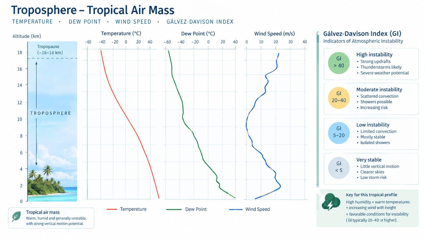
A surface dew point answers a limited question: how much moisture is present near the reporting station? It doesn't establish whether that moisture extends through the cloud-producing layers above it.
The vertical-profile approach compares temperature, dew point, and wind at multiple levels. NOAA's Gálvez-Davison Index technical description evaluates conditions at 950, 850, 700, and 500 hPa, accounting for lower- and middle-level thermodynamics, dry-air entrainment, and trade-wind inversions.
Following moisture upward
A student can read the profile as a sequence of questions rather than search for one reassuring surface value:
- Lower layer: How closely do temperature and dew point track, and what cloud-base environment does that suggest?
- Middle levels: Does moisture continue upward, or does a pronounced dry layer appear?
- Temperature structure: Is there an inversion or another stable layer that could limit ascent?
- Wind structure: How do wind speed and direction change through the layers relevant to the flight?
A moist lower layer beneath dry air aloft deserves attention. When precipitation enters dry air, evaporation can produce substantial cooling and strong downdrafts. Deep moisture, by contrast, can support more persistent, vertically developed convection when instability and lift are present.
Why surface warmth isn't enough
Condensation during saturated ascent releases latent heat, contributing to the rising parcel's buoyancy. The NOAA thermodynamic explanation underlying the vertical approach describes roughly 45 K of latent-heating contribution for a typical tropical parcel ascending from the surface into the upper troposphere, as discussed in the technical reference above. That isn't a prediction that the surface will warm by that amount.
Observed tropical profiles also vary substantially. A peer-reviewed analysis of tropical Atlantic and Caribbean soundings examined roughly 6,000 observations and distinguished moist tropical air, Saharan air layer conditions, and midlatitude dry-air intrusions. Those regimes represented 66%, 20%, and 14% of the dataset, respectively.
A humid surface observation doesn't establish a uniformly humid atmosphere.
The cockpit lesson is to identify dry layers and inversions before interpreting cloud development. Mature convection can involve turbulence, lightning, hail, heavy precipitation, and icing within its clouds. Reviewing icing conditions helps connect the profile with an aircraft-specific hazard assessment rather than assuming warm surface air eliminates concerns aloft.
A Southern California Scenario With an mT Intrusion
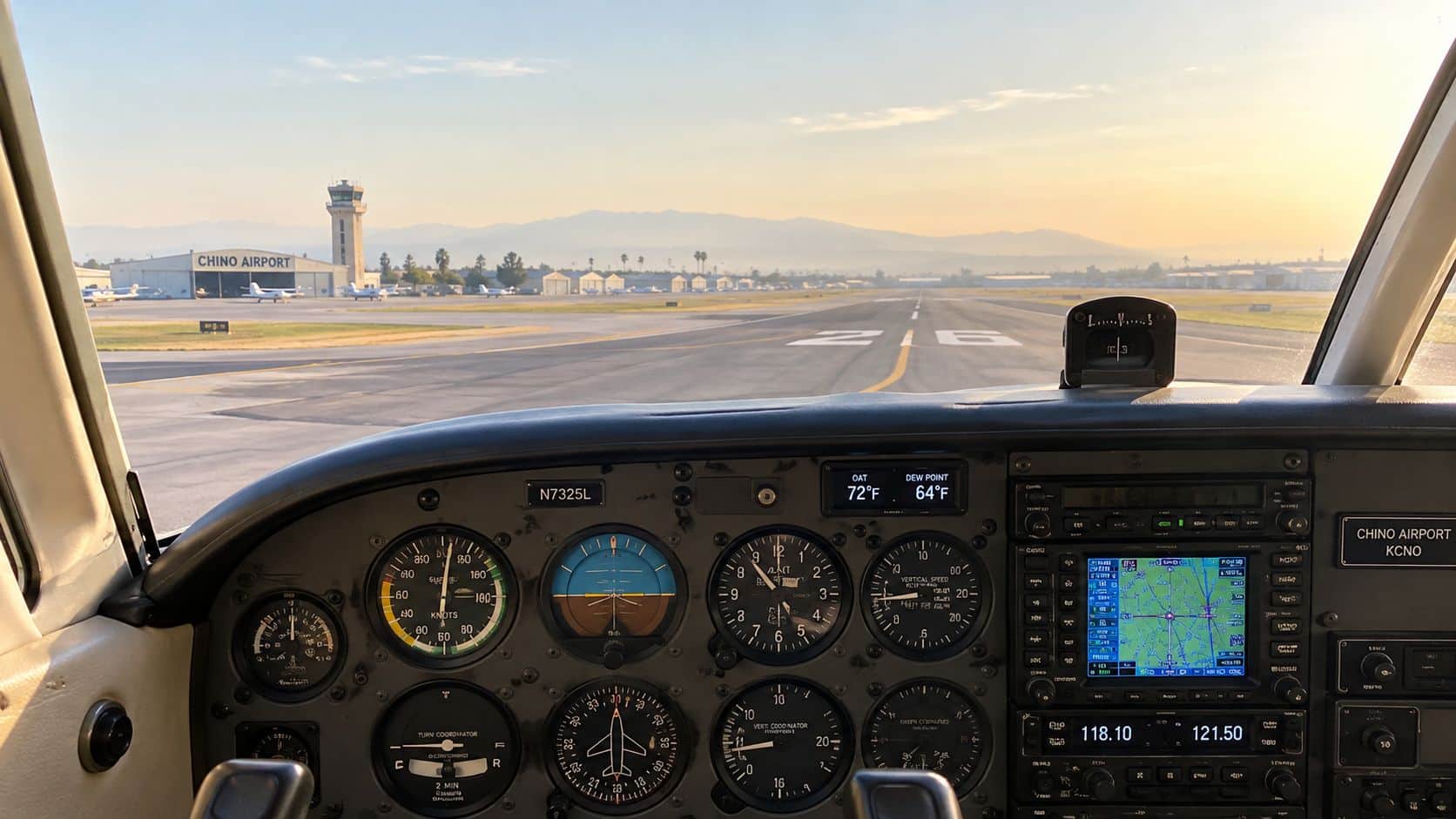
Consider a hypothetical summer training flight from Chino Airport, not a report of an actual flight. Morning observations show increasing dew points and haze, scattered cumulus is developing over the Santa Ana Mountains, and the relevant terminal forecasts indicate an afternoon convective threat.
The departure weather is acceptable for the proposed flight. The question is whether it will remain acceptable through the planned return.
Before departure
The student and instructor compare the observations with the vertical profile. A moist lower layer and forecast terrain-triggered convection make an extended afternoon maneuver session less attractive than a short morning flight.
They also evaluate takeoff and climb performance for the actual loading and expected temperature. The process uses the aircraft's approved information, with aircraft performance charts providing a useful training reference for organizing that calculation.
Their plan includes an early return and possible diversion toward Ontario or Corona. Neither airport is automatically a safe alternative merely because it is nearby; current weather, runway suitability, access, and the aircraft's remaining fuel must support the choice.
The preflight discussion identifies observable reasons to stop the lesson:
- Cloud development: Vertical growth near the planned practice area becomes more pronounced.
- Route deterioration: The return corridor loses acceptable ceiling or visibility margins.
- Wind changes: Gusts or shifting winds make the planned landing less suitable.
During the flight
In this example, the crew sees growing clouds over the terrain and compares them with available radar imagery and ADS-B weather. They use those displays to reassess the overall pattern, not to justify squeezing between developing cells.
The warm, moist layer provides the starting environment, while terrain supplies a potential lifting mechanism. Local sea-breeze and mountain-flow changes are additional features to monitor, rather than assumed explanations for every cloud or gust.
The crew chooses an early return while the airport and route remain suitable. Later in the hypothetical afternoon, a gust front brings a wind shift that would have complicated the original return plan.
The outcome is a shortened lesson and a delay of further flying, not a dramatic escape. NOAA's aviation hazard data identify threats including embedded thunderstorms, strong winds, and low-level wind shear. The sensible training decision is to avoid needing a last-minute solution to those hazards.
Preflight and En Route Checks in Tropical Air
A tropical-air briefing should produce decisions, not merely a list of products viewed. The pilot needs to connect each forecast concern with a route choice, aircraft limitation, personal minimum, or contingency.
The following checks are planning recommendations, not a substitute for applicable FAA requirements or aircraft limitations. Weather products are time-sensitive, so their issuance times, valid periods, and updates belong in the briefing.
During flight planning
- Terminal trends: Compare departure, destination, and potential alternate TAFs across the entire expected flight period.
- Route hazards: Review applicable AIRMETs, SIGMETs, Convective SIGMETs, and graphical forecasts, including areas between airports.
- Performance: Calculate density altitude effects and aircraft performance for anticipated conditions and loading.
- Escape options: Identify usable alternatives and sufficient fuel flexibility before selecting the route.
- Decision points: Establish what forecast change would justify delaying departure or shortening the flight.
The Aviation Weather Center's Graphical Forecasts for Aviation guidance explains that any Convective SIGMET implies severe or greater turbulence, severe icing, and low-level wind shear. It also describes qualifying convection, including a thunderstorm line at least 60 miles long with storms affecting at least 40 percent of its length, and qualifying embedded or severe thunderstorms expected to persist for more than 30 minutes.
These are product criteria, not safe operating thresholds. A pilot shouldn't interpret the absence of a Convective SIGMET as evidence that a particular developing cell is harmless.
On the ramp
A final check should test whether the atmosphere is developing as forecast. A simple briefing sketch can mark the moist layer, any inversion, a dry layer aloft, and the expected lifting area.
| Check | Decision it supports |
|---|---|
| Temperature and dew point | Whether visibility and cloud-base assumptions remain reasonable |
| Radar and satellite trends | Whether precipitation and cloud development are changing the route |
| Winds aloft and surface winds | Whether routing and landing options remain suitable |
| Relevant PIREPs | Whether pilots are encountering hazards not obvious from surface observations |
| Updated advisories | Whether the original departure decision still holds |
In the air
The pilot should monitor ceilings, visibility, cloud growth, precipitation, and winds while maintaining a usable alternative. Turbulence, reported icing, lightning, or evidence of wind shear should trigger reassessment rather than an attempt to finish the planned lesson.
Decision standard: A diversion is most useful while the alternative remains comfortably reachable.
A written set of go/no-go criteria can make that decision less dependent on optimism. The checklist should specify when to delay, when to return, and when to divert, including what to do if the destination remains clear but the route no longer does.
When Tropical Air Stays Stable and Benign
Tropical air doesn't automatically produce thunderstorms. The missing ingredients may be instability, a lifting mechanism, or both.
The FAA's aviation-weather guidance on air masses explains that warm, moist maritime tropical air moving over a colder surface cools from below and becomes stable. Stratiform clouds, fog, and drizzle can result instead of towering convective clouds.
Stable doesn't mean suitable for every flight
This distinction matters because the visual appearance can be less dramatic than a thunderstorm while still presenting a serious operational problem. A widespread low ceiling may prevent a planned visual route or remove comfortable margins around terrain.
For an instrument flight, the question shifts to whether the aircraft, pilot, route, and available approaches support the conditions. An instrument rating doesn't make every low-cloud situation suitable, just as clear departure weather doesn't establish suitable conditions at the destination.
A cooler coastal surface offers a useful Southern California teaching example. Incoming warm, moist air may encounter an environment that favors lower-layer stability rather than deep convection. That possibility must be checked against the actual forecast, not assumed from a marine-layer appearance.
Contrasting the weather outcomes
| Atmospheric setup | Likely briefing emphasis |
|---|---|
| Moist air cooled from below | Low ceilings, fog, drizzle, visibility |
| Moist air with a limiting inversion | Cloud beneath the cap and uncertainty about whether the cap persists |
| Moist air over a warmer surface with lift | Potential instability and vertical cloud development |
| Warm air without forecast hazardous cloud or precipitation | Performance planning and continued trend monitoring |
Warm, humid air over a warmer surface is more likely to maintain or increase instability, especially when terrain, a front, or daytime heating supports ascent. The outcome still depends on the full profile.
The most useful forecast questions are therefore specific:
- Ceilings: Will the cloud layer affect the intended route or arrival?
- Visibility: Are haze, fog, or precipitation expected to restrict it?
- Stability: Is the limiting layer forecast to persist or weaken?
- Timing: Could acceptable morning conditions become unsuitable before the return?
Calling the air stable describes its resistance to vertical motion. It doesn't describe the pilot's qualifications, aircraft equipment, or available weather margins. Stable tropical air can be relatively benign meteorologically while remaining an instrument meteorological conditions threat to a visual flight.
Pilot Takeaways and FAQs on Tropical Air Mass
The essential habits are to identify the source region, account for modification over the current surface, and assess stability level by level. The label establishes context; observations and forecasts support the flight decision.
Does tropical air always raise density altitude and hurt climb performance?
Not automatically. Temperature, airport conditions, and aircraft loading require an actual performance calculation; the classification alone can't establish the available climb margin.
How far from a tropical system can a training flight be affected?
There isn't a single useful distance. Moisture plumes, outer rainbands, outflow, and changing ceilings deserve attention beyond the center's forecast track.
NOAA's 2025 global climate summary reported 101 named tropical storms worldwide, compared with a 1991–2020 average of 88. Tropical-weather awareness remains relevant even for pilots operating far from a cyclone center.
Can a tropical air mass produce clear VFR weather?
Yes. The label doesn't require cloud or thunderstorms. The pilot still needs suitable visibility, ceilings, performance margins, and route forecasts.
What's the simplest single preflight tool?
The Graphical Forecasts for Aviation display is a useful starting point for comparing route conditions and hazards. It isn't a complete briefing by itself; terminal forecasts, advisories, observations, and the vertical profile supply necessary detail.
DuBois Aviation offers airplane and helicopter instruction, instrument and advanced training, and aircraft rental at Chino Airport. Prospective students and certificated pilots can visit DuBois Aviation to request training information, ask about course availability, or schedule a school tour focused on building practical weather-briefing and flight-decision skills.